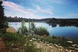
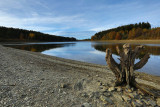
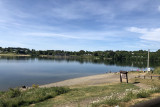
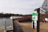
Destination: Bütgenbach lake


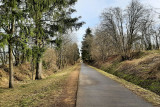
Departure will be near the old station of Sourbrodt, to reach, via the Vennbahn, node point 44. Between Sourbrodt and Bütgenbach, the small, pleasant, and gently sloping paths offer breathtaking views of the Warche valley.
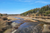
Join the RAVel along Line 45a towards Bütgenbach lake. This resort-like village reveals unspoiled nature, large forests, vast green expanses, magnificent bocages, and nature reserves that are worthy of preservation.
You have two choices: you can ride around the lake, taking the 10 kilometer path along the banks that departs from node point 17, or you can relax on one of the lake’s beaches and enjoy a picnic. The various options can obviously be combined.
After a well-earned break, rejoin the RAVel to calmly return to your starting point.
Eat and drink: Nidrum, Elsenborn, Bütgenbach
- Difficulty: Easy
- Elevation: 169 m
- Distance: 24,5 km (or 34,5 km if variant)
- Starting point: Rue des Tourbières (at the level crossing near the crossroads with rue de la Croix Marquet) - 4950 Waimes (Sourbrodt)
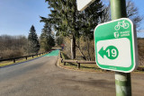
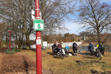
- Node points to follow: 43 → 44 → 87 → 16 → 17 → 18 → 17 → 16 → 15 → 14 → 46 → 45 → 44 → 43
- Variant: Possibility of cycling around Bütgenbach lake from node-point 17 (+10 km). Head towards the dam and follow the path along the banks
- Download the walk
Itinéraire

 Departure/Arrival
 Point of interest
Circuit n° 1
Nodes to follow43 → 44 → 87 → 16 → 17 → 18 → 17 → 16 → 15 → 14 → 46 → 45 → 44 → 43
 |
- Difficulty :
- Easy
- Height variation :
- 169 m
- Distance :
- 24,5 kms
- Departure :
- Lieu de départ Waimes (Sourbrodt)