Mehaigne & Burdinale


This loop is formed by the big gap between agricultural plateaus: the very deep valley of the Burdinale and the wooded valley of the Mehaigne.
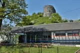
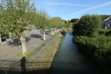
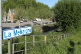
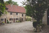
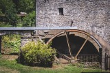
The bike ride through the limestone valley of the Mehaigne, between Huccorgne and Moha castle, allows you to discover marvels such as the Marquise rock or the Roche aux Corneilles. There are also three tourist and heritage sites: Moha castle, the Ferrières watermill, and the Hirondelle estate (camp-site).
This loop is very hilly and quite physically demanding. However, the paths involved are well maintained.
Eat and drink: in Oteppe
- Difficulty: Easy
- Elevation: 138 m
- Distance: 25 km
- Starting point: Place Galloy in Moha
- Node points to follow: 38 → 85 → 87 → 83 → 82 → 75 → 76 → 37 → 38
- Download the walk
Itinéraire

 Departure/Arrival
 Point of interest
Circuit n° 1
Nodes to follow38 → 85 → 87 → 83 → 82 → 75 → 76 → 37 → 38
- Difficulty :
- Easy
- Height variation :
- 138 m
- Distance :
- 25 kms
- Departure :
- Lieu de départ Moha