Mehaigne & Moissons

  • Cycling and hiking tours - Mehaigne & Moissons - Fallais Castle
  • Cycling and hiking tours - Mehaigne & Moissons - Fallais Castle
  • Cycling and hiking tours - Mehaigne & Moissons - Hesbaye - Campaigns - Cyclists
  • Cycling and hiking tours - Mehaigne & Moissons - The Saule village - MMER
  • Cycling and hiking tours - Mehaigne & Moissons - Fallais - RAVeL
  • Cycling and hiking tours - Mehaigne & Moissons - Ville-en-Hesbaye - The Bolland stream
  • Cycling and hiking tours - Mehaigne & Moissons - Hesbaye - Campaigns - Cyclists - Vissoul
Cycling and hiking tours - Mehaigne & Moissons - Fallais CastleCycling and hiking tours - Mehaigne & Moissons - Fallais CastleCycling and hiking tours - Mehaigne & Moissons - Hesbaye - Campaigns - CyclistsCycling and hiking tours - Mehaigne & Moissons - The Saule village - MMERCycling and hiking tours - Mehaigne & Moissons - Fallais - RAVeLCycling and hiking tours - Mehaigne & Moissons - Ville-en-Hesbaye - The Bolland streamCycling and hiking tours - Mehaigne & Moissons - Hesbaye - Campaigns - Cyclists - Vissoul
Warnings!
A section of this route has been affected by renovation work being performed on Line 127 of the RAVeL network between Hannut and Huccorgne since Monday 17 April.
The following points are affected: 24 → 25 → 29 → 30 → 31 → 32 → 33 → 34 → 35 → 36 → 37 → 38.
This work will be divided into eight phases. Each phase will take approximately three weeks. Local diversions will be planned for each phase. Please follow the orange detour signs (RAVeL). Completion end of August.

Departing from Fumal, discover the villages of Marneffe and Vissoul as you travel across well-preserved and colorful agricultural landscapes.
Next, travel through Ville-en-Hesbaye to join Val de Mehaigne via a wooded route, which passes some remarkable sites like Fallais castle and the village of Saule.

Eat and drink: in Oteppe and Fallais

  • Difficulty: Easy
  • Elevation: 68 m
  • Distance: 18 km
  • Starting point: Place de Limage-Fumal (near the RAVeL)
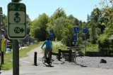
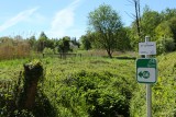
  • Node points to follow: 37 → 76 → 75 → 74 → 73 → 66 → 67 → 68 → 33 → 34 → 35 → 36 → 37
  • Download the walk
Itinéraire
loading
- Departure/Arrival
- Point of interest
Circuit n° 1
Nodes to follow37 → 76 → 75 → 74 → 73 → 66 → 67 → 68 → 33 → 34 → 35 → 36 → 37
  • Difficulty :
    • Easy
  • Height variation :
    • 68 m
  • Distance :
    • 18 kms
  • Departure :
    • Lieu de départ Fumal