The large High Fens Circuit


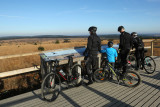
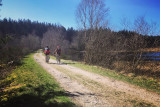
Departing from the Maison du Parc Naturel in Botrange, you cycle towards Belgium’s highest point before descending to the Fagne de Cléfaye. Don’t hesitate to stop and admire the two pretty viewpoints on either side of the Walloon Fens.
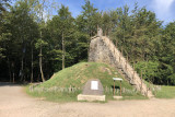
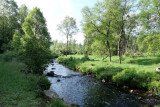
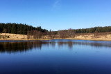
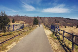
Halfway along the route, near the Bergervenn, you’ll come across the Schwarzsee Lake, named for the dark colour of its water. As you head towards the German border, you’ll notice that an authentic railway carriage from the 1950s has been converted into a restaurant along the Vennbahn RAVeL. You then make your way leisurely up the Vennbahn, passing the Schwarzes Venn, the Fagne de la Roer, where the RAVeL had to make a diversion because of the presence of an endangered species of bird, and the Rurhof peat bog, which is almost 4 metres thick.
Eat and drink: Brasserie Le Mont Rigi (Route de Botrange, 135 - 4950 Waimes)
- Difficulty: Difficult
- Elevation: 462 m
- Distance: 37 km
- Starting point: Route de Botrange, 131 (Maison du Parc-Botrange) - 4950 Waimes
- Node points to follow: 50 → 52 → 51 → 80 → 83 → 84 → 85 → 63 → 71 → 72 → 38 → 42 → 43 → 79 → 80 → 51 → 50
- Download the walk
Itinéraire

 Departure/Arrival
 Point of interest
Circuit n° 1
Nodes to follow50 → 52 → 51 → 80 → 83 → 84 → 85 → 63 → 71 → 72 → 38 → 42 → 43 → 79 → 80 → 51 → 50
 |
- Difficulty :
- Difficult
- Height variation :
- 462 m
- Distance :
- 37 kms
- Departure :
- Lieu de départ Waimes